Backcountry snowkite spot above Vaujany, in the Grandes Rousses massif (Isère, France). Col du Sabot (2,100 m) is a narrow V-shaped pass between the Eau d'Olle valley (Vaujany side, Lac du Verney) and the Grand-Maison dam / Col de la Croix de Fer side. Stunning mountain atmosphere with exceptional panoramic views: Dôme des Petites Rousses and Aiguillettes de Vaujany on one side, Grand-Maison lake and Mont Blanc on the other.
The spot works in north and south wind. In south wind (most common), the wind picks up well from the first plateau above the forest. In north wind, it channels from Grand-Maison lake up the valley, generously feeding the Rissiou area and Aiguillettes like a funnel.
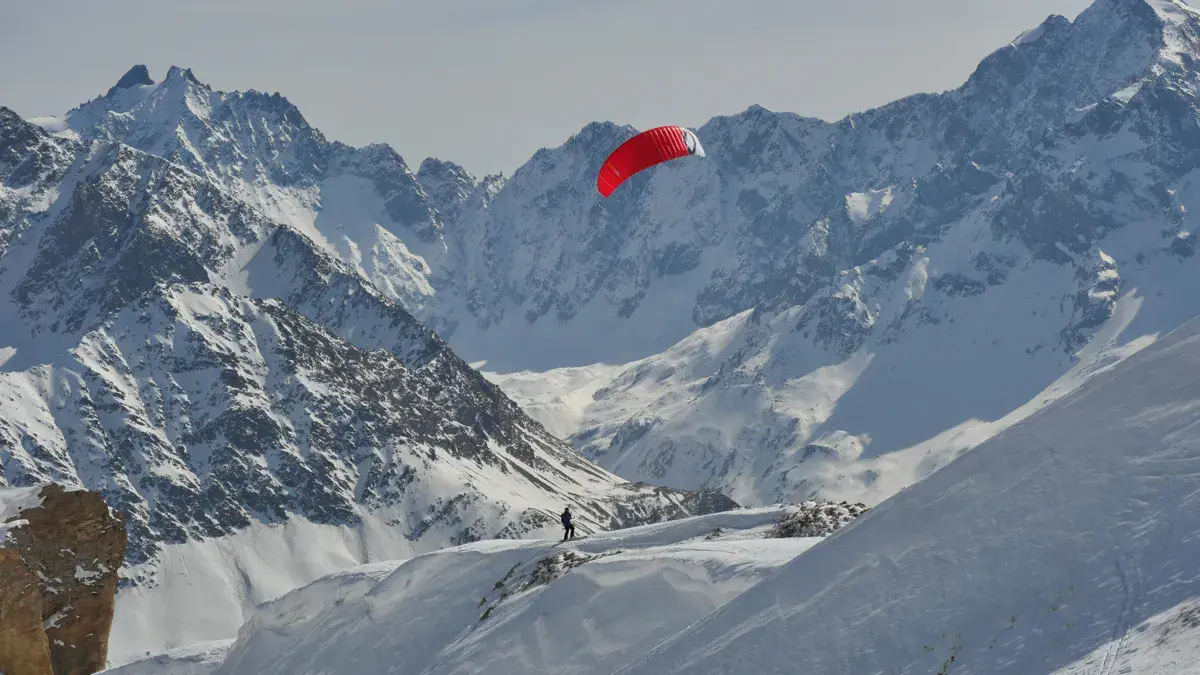
Access requires 1 to 1.5 hours of hiking with touring skins from La Villette parking (1,400 m), making it a selective but peaceful spot with far fewer people than roadside spots. Great mountain atmosphere and guaranteed solitude. Thermal wind possible late season (May).
About 1 hour drive from Grenoble via Bourg-d'Oisans and the Eau d'Olle valley.
Onekite – Isère-based kitesurfing, snowkite and powerkite association
FFVL – French Free Flight Federation
Backcountry kite-touring only, no lifts. Ascent on touring skins from La Villette or the Collet parking depending on snow cover and winter road closure.
Launch kites as soon as you exit the forest above the parking when wind is sufficient. The riding area extends across the plateaus and alpine pastures up towards the col.
Possible to explore the Aiguillettes de Vaujany slopes in north wind, or push towards the Croix de Fer area on the south side of the col.
Open all year round
Freeride (Ski touring access)
Altitude: 1976m
From Grenoble, head to Bourg-d'Oisans then up the Eau d'Olle valley via the D526 towards Allemont and Col de la Croix de Fer. Turn right onto the D43a towards Vaujany. Drive past the village to the Collet parking (1,405 m), end of the road.
In winter, the road is closed from the tennis parking at La Villette. Start on foot from there. Allow 1 to 1.5 hours for the ascent on touring skins (700 m elevation gain).
North and south are the two main wind directions.
South wind (most common for this spot): doesn't pick up well until the first plateau above the forest. The higher you go, the more consistent the wind. Technical but very rewarding sessions.
North wind: channels from Grand-Maison lake and funnels up the northern valley of the Sabot. Generously feeds the Rissiou area and Aiguillettes de Vaujany. Uphill tacking possible.
Thermals: possible late season (late February to May), valley breeze effect enabling riding even in calm high-altitude conditions.
The narrow V-shaped col significantly accelerates wind — size your kites accordingly.
Avalanches: do not follow the snow-covered road to Col du Sabot in winter — it runs close to the steep Rissiou slopes and is exposed to slides. Follow the ski touring route instead. Avalanche transceiver, shovel and probe recommended.
Strong wind: the narrow V-shaped col accelerates wind significantly. Bring appropriately sized kites.
Fog: surrounding peaks often get clouded in north wind. Visibility can drop suddenly.
Altitude and cold: 2,100 m, frequent icy wind, dress warmly.
Wind drop: bring touring skins for the return — the spot is remote.
If you notice any outdated information:
Suggest an editLive data from TMX weather station (wind, gusts, history) is reserved for Premium members.
Already a Premium member? Log in
Loading webcams...
Comments 0
Login to commentNo comments yet.